We all have used Google Maps for various rides, and other than navigating, the application also informs us of the shorter and longer routes respective to our destination. With travel becoming the primary and major part of our daily routine, information through this application can reach out to millions of people with just one click. What if you get to know soon that you will be able to know the routes that will be eco-friendly and friendly for your pocket too? These pathways will inform the citizen about the quality of air, harmful pollens, capacity of solar panels, and microclimate of the region with respect to buildings roofs and tree canopy of the region. In addition, citizens will also be informed of the most fuel-efficient and potentially less carbon footprint routes. Recently, Google Maps has launched various environment APIs, mainly for European countries. These APIs will promote “eco-conscious” choices for citizens.
Indians have the second-largest work force population in the world, which is eager and extremely ambitious. This section of the population is keen on and aware of global agendas and conferences. The global push towards sustainable living and development is much discussed by this population. The combining of such rich data with Google Maps will help ambitious individuals, cities, and partners collectively understand the global urgency of climate change. This could be the easiest pathway to reach out to every household in every corner of the country and inform them about climate change.
To understand the impact of climate change, this platform will build experiences that pave the way for a sustainable future for the next generation. The new suite of Environment APIs, including solar, air quality, pollen, canopy cover and eco-friendly routes, will encourage people to embrace new environmental realities.
ENVIRONMENT API’S ON YOUR FINGER TIPS
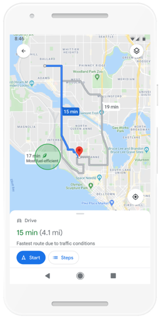
Eco-friendly routes– Google Maps now suggests fuel-efficient routes based on traffic congestion history, fewer hills, constant speeds, and reduced carbon emissions. These will make users and stakeholders aware of routes that will be eco-friendly and energy-efficient for them. This feature can subsequently promote offsetting the carbon emissions on roads. Google has also leveraged this technology related to electric vehicles for insights on prices and nearby charging stations. These routes will be displayed with a small green leaf next to the routes.
Solar– This feature has two distinct functionalities to help all kinds of solar companies address solar viability and design. This data will encourage citizens and institutions to adopt solar panels, which can further contribute to sustainable cities. Solar information for the buildings provides quick insights into solar feasibility, such as the amount of sunlight a building receives and the most energy-efficient solar panel array. This data can provide free insights to the citizens on the shading that affect the solar panel performance for their buildings.
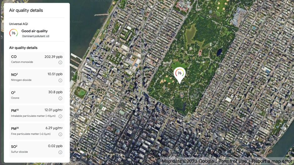
Air quality– For environment enthusiasts, companies, and decision-makers, this feature can help with a brief understanding of climate and environmental changes for various locations. This will also alarm citizens with respiratory issues to take necessary precautions against heavy pollutants. This will encourage informed choices, advocate for change, and help mitigate impacts.
https://cloud.google.com/blog/products/maps-platform/going-beyond-map-introducing-environment-apis/
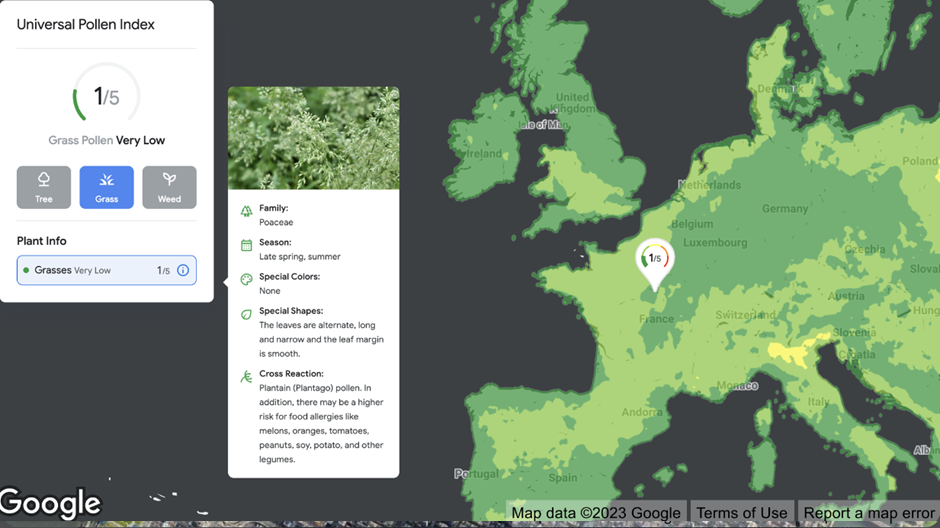
Pollen– There are various pollens generated in different seasons and few of these airborne particles are allergic. In India, due to exposure to some pollens, people suffer from rhinitis, asthma, and atopic dermatitis. Thus, this feature will provide information about the real-time spread of pollen in the area. This API will help facilitate a healthy environment for people. Also, provide localized pollen count data, detailed plant allergen information, and actionable tips for allergy sufferers to limit exposure and help users make healthier decisions.
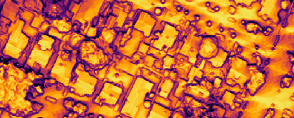
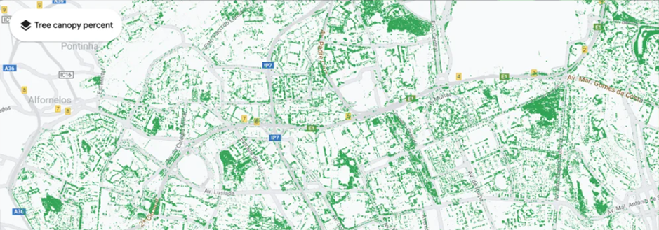
Canopy Cover– Urban vegetation provides numerous benefits. The ability to create shade and reduce the urban heat island effect, stop airborne polluting particles and purify the air, and offset at least some of the carbon emissions by absorbing carbon dioxide is given by city trees. Citizens can track their surroundings and be informed by area. Tree canopy, part of our environment insights explorer, combines AI and aerial imagery so cities can understand their current tree coverage and better plan forestry initiatives[1]. Many municipalities of cities in India have also adopted to prepare “Urban Forestry Plan” and the launch of this feature in Google Maps will make citizens of Indian cities aware of the importance of this plan.
These sustainable paths from Google Maps will guide the Indian population with real-time updates on their surroundings and environment. This functionality will specifically reduce harmful greenhouse gas emissions. Can’t wait for these APIs to be launched for Indian streets and localities!

Written by:
Nupur Choudhari
Urban Planner at Terracon Ecotech
Reference links
[1] https://timesofindia.indiatimes.com/gadgets-news/5-google-maps-tips-for-eco-friendly-travel/articleshow/105257320.cms
[2] https://www.prakati.in/google-maps-will-soon-start-showing-eco-friendly-route-options/
[3] https://blog.google/outreach-initiatives/sustainability/extreme-heat-support/
